Author: V. Iyengar, Megaphone Editor-in-chief
📍San Francisco, CA
The United States gained possession of Alcatraz, along with the rest of California in 1848, following the Mexican-American War, and since then, the island has accrued a rich, and deep history.
History of Alcatraz
In 1850, President Millard Fillmore ordered that Alcatraz be set aside as a military reservation to be used by the American Military. From there, construction on the island began, and Fort Alcatraz was completed in 1858.
Two years later, during the Civil War, Alcatraz was used not only as a fort, but also as storage for firearms, to keep them away from Confederate sympathizers in the San Francisco Area. Alcatraz’s foundations as a prison began to sprout during this time, as Fort Alcatraz was also being used to imprison captured Confederate sympathizers and other prisoners of war caught on the West Coast.
The Civil War ended in 1865, but Alcatraz’s potential as a prison began to expand, and in 1867, the first jailhouse was built on the island (previously, prisoners were stored in the basement of where the prison guards lived). In 1895, some Hopi Native American men were sent to Alcatraz for refusing to send their children to boarding schools, which was a provision of the Dawes Act of 1887, passed with the intent of forcing Native Americans to “assimilate”.
One year, later, Alcatraz was finally designated as a prison, and from 1909 to 1934, further construction on Alcatraz took place, with the army tearing down structures such as Alcatraz’s Citadel to make space for the foundation of the new prison.
In 1934, construction was finished, and Alcatraz was officially designated a federal prison, ushering the most well-known era of Alcatraz, a prison made to hold inmates who caused trouble at other federal prisons. Alcatraz went on to gain international notoriety as one of the most brutal and inescapable prisons out there, holding some of the nation’s most violent criminals, like George “Machine Gun” Kelly Barnes, Robert Stroud, and Al Capone, up until its official closure in 1963, which was mainly the result of high costs of operation.
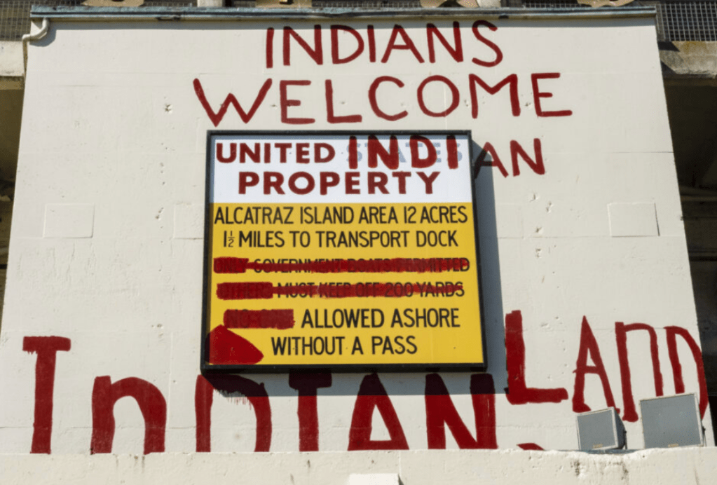
Later, in 1969, the island was occupied by a group of Native Americans under the group United Indians of All Tribes, in protest of federal policies related to American Indians that encouraged assimilation. The Natives stayed there for 19 months until 1971, when 15 native Americans were forcibly removed from the island by the FBI.
Less than a year later, in 1972, the National Park Service purchased Alcatraz and established it as a part of the Golden Gate Recreational Area, where Alcatraz now stands as an iconic tourist site and museum.
In recent years, experts warn that Alcatraz is greatly threatened by rapidly rising sea levels. On a mission to preserve and protect Alcatraz’s history, a team based in Seattle, VCTO Labs, created an incredibly realistic 3D map of the island.
Making the Map
Before embarking on the process of collecting data for the map, VCTO Labs needed permission for the project, which took nine months to obtain because the team had to wait until nesting season to fly drones. Otherwise, they’d risk causing a disturbance to the island’s bird population. Once everything else was sorted out, in December 2023, the team from VCTO Labs assembled at Alcatraz, and the process of making the map began.
To create the map, the company mainly used drone-based LiDAR, which employs the use of lasers to map the surface of the island. However, in many cases, people aren’t allowed to enter certain spaces due to asbestos, lead paint, or structural damage. Additionally, some places on the island are inaccessible to humans because entire staircases and parts of floors are missing. In such cases, Flyability’s E3 drone was used for dangerous, confined spaces which humans could not safely enter, and captured video and LiDAR data at the same time. Additionally, Spot, the robot dog from Boston Dynamics went into hazardous spaces where the airflow created by the drone would have kicked up asbestos and lead contamination. After all of the data was collected, it was then processed by an AMD supercomputer.
Interestingly, while collecting data for the map, the team from VCTO Labs slept in the very cells that once housed some of America’s most dangerous prisoners. Pete Kelsey, the founder of VCTO Labs, slept in cell 31, and commented that the stay was unpleasant. To a blog post published on VCTO Labs’ website about the project, Kelsey wrote: “Sleeping on Alcatraz for almost three weeks was an interesting experience. You hear everything. My team members’ every move, every bodily function, snoring, bad dreams. The sounds of the bay. Fog horns, wind and rain, a distant bell buoy. I slept well once I secured a mosquito net. The first night the bugs ate us alive.”
Applications for the Project
Rising sea levels pose a dangerous threat to Alcatraz. According to GGNRA archaeologist Peter Gavette, this map can be used as a baseline map. As Gavette explained to CBS News, “There are portions of the island that are eroding and with this pinpoint in time we’ll be able to do future scans and see what has changed and what parts of the island has had more impacts than others.”
Kelsey hopes that the map will help the public better understand the impacts of climate change, and make people more aware of all of the dangers that come with ocean warming and rising sea levels.
Additionally, the GGNRA wants to preserve Alcatraz’s history as not only a prison, but as a protest site for Native Americans back in the 1960s. Remnants of these Native American protests can still be seen in the form of graffiti, such as is pictured below. Researchers hope to preserve these physical aspects of the island from possible damage caused by climate change.
Beyond the map’s scientific and historical value, Kelsey hopes that movie studios will also be able to use it as a 3D green screen, or it could be applied to a video game for Apple Vision Pro, or even the world’s first virtual natural park.
